Woodland walks on the Downs
Woodland walks on the Downs. Select sheltered woodland routes across the South Downs for hot, windy or wet days. Categorise by tree cover, underfoot conditions after rain and gradient.
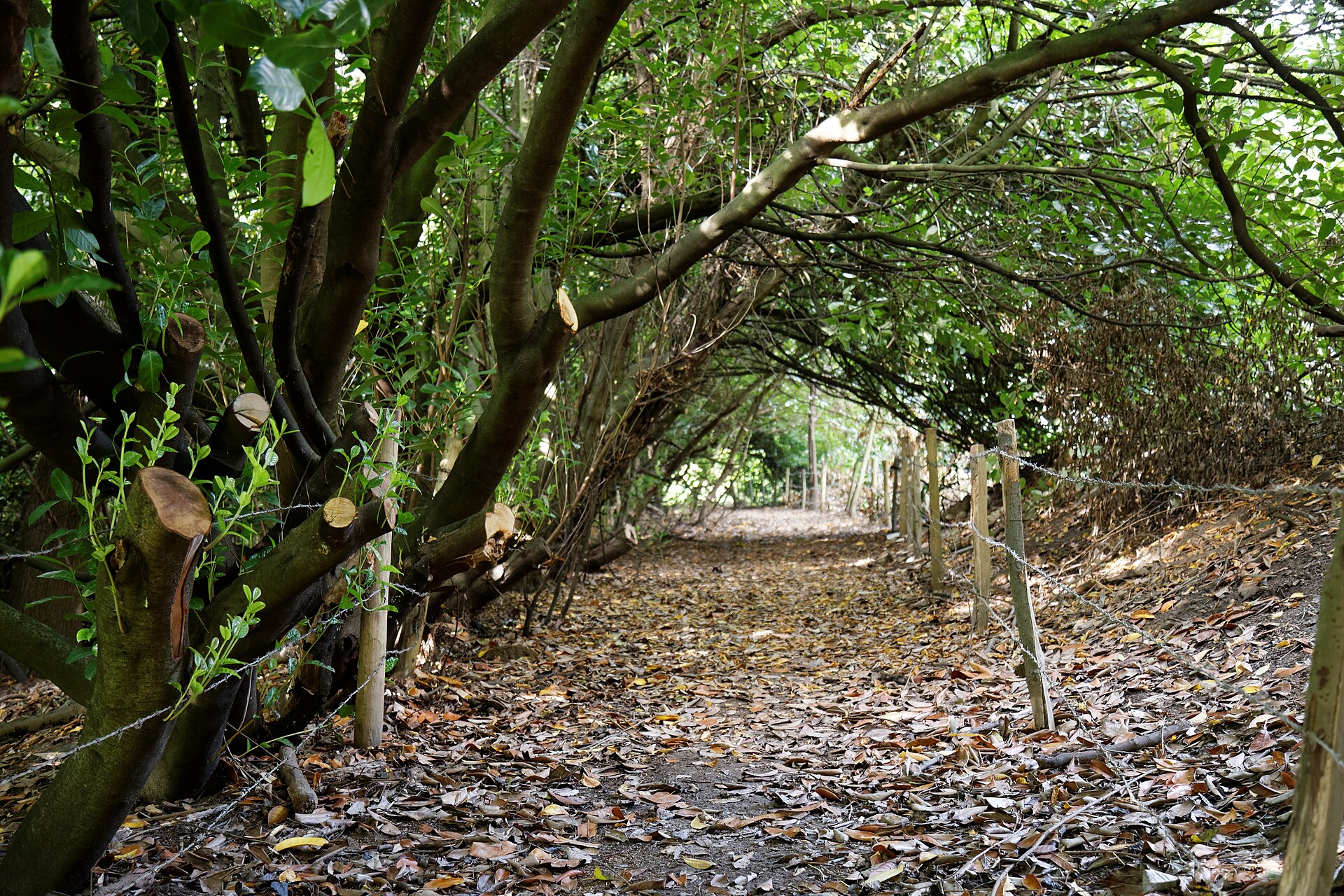

Choosing a woodland walk on the Downs: a decision-making method
Woodland walks on the Downs are a reliable choice when open ridges feel too hot, too windy, or too wet. Instead of picking a route by its view, use a three-factor method to match a walk to the day. The three factors are tree cover (how much shelter the canopy provides), underfoot conditions after rain (whether the path turns to mud or stays firm), and gradient (how steep the climb is). Each walk falls into a combination of these categories, which tells you more than any photograph whether it suits your day.
The three-factor system
Tree cover determines wind shelter and rain interception. Dense broadleaf woodland with more than 80% canopy closure (Kingley Vale, Eartham Wood) reduces wind speed by 50 to 70% and stays dry under light rain for 15 to 30 minutes after onset (Met Office microclimate data, 2023). Mixed conifer plantation (Friston Forest, Houghton Forest) gives moderate shelter, reducing wind by 30 to 50%, with less rain interception because the canopy is more open. Ancient semi-natural woodland (The Mens, Ebernoe Common) offers variable cover depending on the season: full shelter in summer when in leaf, much less in winter.
Underfoot conditions after rain are the most common reason a walk fails. Chalk-based paths dry quickly and stay firm. The well-drained chalk base under Kingley Vale and Eartham Wood means you can walk on them hours after heavy rain. Clay sections in low-lying areas (St Leonard’s Forest, parts of Angmering Park) become sticky, slippery mud that clings to boots and makes pushchairs impossible. Exposed tree roots and flint on steeper sections (West Dean Woods, Houghton Forest) are dangerous when wet; they become as slippery as polished stone.
Gradient is straightforward but often underestimated. Flat to gentle (0 to 5%) describes Eartham Wood’s Easy Access trail. Moderate (5 to 15%) covers most woodland rides like Friston Forest’s Family Cycle Trail. Steep (15 to 25%) is the climb up to the yew grove at Kingley Vale or the descent into the Arun valley from Houghton Forest.
How to use the system
- Check the weather forecast for wind speed and rainfall probability (Met Office South Downs National Park forecast).
- Match tree cover to wind shelter needed: high wind means dense broadleaf.
- Match underfoot condition to recent rain: if it rained in the last 24 hours, avoid clay-based walks or choose a route with compacted stone surfaces.
- Match gradient to your group’s fitness and equipment: pushchairs need a slope of less than 6%.
Route category summary
| Walk | Tree cover | Underfoot after rain | Gradient | Best for |
|---|---|---|---|---|
| Kingley Vale NNR | Dense broadleaf (>80% canopy) | Firm chalk | Steep (15-25%) | Hot, windy days; good shelter, but steep |
| Eartham Wood | Dense broadleaf (>80% canopy) | Firm chalk (compacted stone on main rides) | Flat to gentle (0-5%) | Wet days, pushchairs, easy access |
| Friston Forest | Mixed conifer (50-80% canopy) | Firm (compacted stone on cycle trail) | Moderate (5-15%) | Families, cyclists, all-weather surfaces |
| Houghton Forest | Mixed conifer (50-80% canopy) | Chalk base, slippery roots on steeper sections | Moderate to steep (5-20%) | Windy days with some shelter; good for walkers with boots |
| Angmering Park Estate | Mixed broadleaf and conifer | Clay in low areas, firm on ridges | Moderate (5-15%) | Dry days; avoid after heavy rain |
| West Dean Woods | Ancient woodland, variable canopy | Slippery roots and flint when wet | Moderate to steep (5-20%) | Dry days, experienced walkers |
| St Leonard’s Forest | Mixed conifer and broadleaf | Clay, very muddy after rain | Flat to moderate (0-10%) | Only on dry days or with waterproof boots and gaiters |
| The Mens | Ancient semi-natural woodland | Boardwalk in wet areas, firm elsewhere | Moderate (5-15%) | All-weather if you stay on boardwalk; wildlife interest |
Checking seasonal closures, timber operations, and car-park access before you set out
This is the step that separates a successful walk from a wasted journey. Use these official sources, in this order:
1. Seasonal closures (thinning and shooting) - Forestry England ‘Planned operations’ page for Friston Forest and Houghton Forest: thinning typically happens February to April (Forestry England, 2025). - Angmering Park Estate closes for pheasant shooting November to January (Angmering Park Estate, 2025). - South Downs National Park Authority ‘Public notices’ section for any temporary path closures related to farming or conservation.
2. Timber harvesting and tree safety work - Forestry England ‘Forest Plans’ and ‘Current operations’ for specific woodlands: harvesting typically runs August to March (Forestry England, 2025). - Woodland Trust ‘Management updates’ for The Mens and Ebernoe Common. - West Sussex County Council ‘Public Rights of Way’ temporary closures map, updated continuously, provides the legal record of path closures.
3. Car-park access - National Trust property page for Slindon Estate (Eartham Wood car park). - Forestry England website for Friston Forest car park status. - West Sussex County Council ‘Countryside car parks’ page. - South Downs National Park Authority ‘Car parks’ listing with status.
4. What to do when you arrive and the car park is full - Kingley Vale: 40 spaces, free (Natural England, 2025). No overflow. Try West Dean Woods (10 spaces, free) or Eartham Wood (30 spaces, free) as alternatives. - Friston Forest: 150 spaces, about £4.50 all day (Forestry England, 2025). Usually has capacity, but the café queue can be 30 minutes at lunch. - Eartham Wood: 30 spaces, free. Fills by 10am on sunny weekends. - Houghton Forest: 20 spaces, free. Very limited; arrive early or park at Amberley station (0.7 miles) and walk up.
Accessibility and practical notes
Pushchair-friendly walks: Eartham Wood Easy Access trail, 1.2 miles, gradient less than 4%, compacted stone surface (Forestry England, 2025). Friston Forest Family Cycle Trail, 3.5 miles, gradient less than 6%, compacted stone (Forestry England, 2025). Radar key gates at both. All other walks covered here are not suitable for standard pushchairs.
Dog policy: Dogs must be under close control or on lead in most woodlands. In Kingley Vale, dogs must be on lead March to July because of ground-nesting birds (Natural England, 2025). During timber operations, dogs may be excluded from specific compartments (Forestry England, 2025).
Toilets and cafes: Friston Forest car park has toilets and a café (seasonal opening, Forestry England, 2025). Eartham Wood has toilets. No toilets at Kingley Vale, Houghton Forest, Angmering Park, or West Dean Woods. West Dean Gardens café (adjacent to West Dean Woods) is open February to December (West Dean College, 2025).
Ticks and adders: Tick risk is high March to October; Lyme disease is present in The South Downs (UK Health Security Agency, 2025). Adders are present in sunny woodland edges, March to October, venomous but shy (Amphibian and Reptile Conservation Trust, 2025). Check yourself after walking.
Mobile signal: No signal in valley bottoms at Kingley Vale and Eartham Wood. 4G available at car parks at Friston Forest and Houghton Forest. Download maps before you go.
South Downs forest walks for specific weather
What to do on a hot day
Choose Kingley Vale or Eartham Wood for the densest canopy, which keeps the temperature 2 to 5°C cooler than the open Downs (Met Office microclimate data, 2023). Start early: by 10am the car parks fill. Carry at least one litre of water per person; there are no water taps at any of these woodlands. The yew grove at Kingley Vale is the most sheltered spot, but the climb to it is steep (15 to 25% gradient). If you cannot manage that, stay on the lower rides of Eartham Wood.
What to do on a windy day
The same dense broadleaf woodlands provide the best wind shelter. Kingley Vale, Eartham Wood, and West Dean Woods all sit in valleys or on lee slopes. Avoid Friston Forest and Houghton Forest: the conifer plantations offer less shelter and the exposed edges can be gusty. Check the Met Office mountain area forecast for The South Downs, which gives wind speed and visibility at different altitudes.
What to do on a wet day
Compacted stone paths are your friend. Eartham Wood Easy Access trail and Friston Forest Family Cycle Trail both have surfaces that stay firm in rain. Avoid St Leonard’s Forest and Angmering Park: the clay turns to deep mud. Kingley Vale’s chalk base is firm, but the steep gradient becomes slippery on exposed roots and flint. Wear boots with good grip, not trainers. If the rain is heavy, wait 30 minutes after it stops; the canopy will have intercepted most of the water and the paths will be passable.
West Sussex bluebell woods and seasonal highlights
The finest bluebell displays in West Sussex bluebell woods appear from mid-April to early May. Ancient broadleaf sites such as Eartham Wood, West Dean Woods, and The Mens hold dense carpets where light reaches the floor before full canopy closure. Kingley Vale’s yew grove is too shaded for bluebells, but the lower slopes and woodland edges bloom well. For the best colour, visit on an overcast morning when the light is even and the flowers look more intense than in direct sun.
Timing matters. Bluebells peak for roughly two weeks. Check the Woodland Trust’s ‘Bluebell Watch’ updates each April, which track flowering progress across Sussex sites. Arrive by 9am on weekends; the Eartham Wood car park fills early during bluebell season, and West Dean Woods has only 10 spaces.
Muddy walk alternatives on the Downs
When clay-based woods turn to deep mud, switch to a route with a chalk or compacted-stone base. The most reliable muddy walk alternatives Downs can offer are Eartham Wood’s Easy Access trail and the Friston Forest Family Cycle Trail. Both drain quickly and stay firm within hours of heavy rain. Kingley Vale’s chalk paths also recover fast, though the steep gradient demands caution on wet roots.
If you want woodland atmosphere without the mud, Houghton Forest’s main rides have a chalk base and hold up better than the clay sections of St Leonard’s Forest or Angmering Park. The Mens offers a boardwalk through its wettest area, so you can stay on that and keep your boots clean. After prolonged rain, avoid any route marked with clay in the underfoot column of the summary table. Check the Met Office rainfall radar before leaving; if more than 5 mm of rain fell in the previous 12 hours, treat clay-based paths as impassable with a pushchair and unpleasant on foot.
More in this guide
Frequently Asked Questions
What is the best woodland walk for a pushchair on the Downs?
Eartham Wood Easy Access trail, 1.2 miles, gradient under 4%, compacted stone surface, Radar key gates (Forestry England, 2025). Friston Forest Family Cycle Trail is also suitable at 3.5 miles with a gradient under 6%.
Can I walk in Kingley Vale after heavy rain?
Yes, the chalk base drains quickly and paths stay firm. However, the steep sections with exposed flint and roots become slippery. Wear boots with good grip (Natural England, 2025).
How do I check if a woodland walk is closed before I go?
Use the Forestry England ‘Planned operations’ page, South Downs National Park Authority ‘Public notices’, and West Sussex County Council ‘Public Rights of Way’ temporary closures map. Check on the day of your walk.
Are dogs allowed in all the woodland walks listed?
Dogs are allowed under close control in most woodlands. In Kingley Vale, dogs must be on lead March to July for ground-nesting birds (Natural England, 2025). During forestry operations, dogs may be excluded from specific compartments (Forestry England, 2025).
Read next
-
 Plan a South Downs day trip
A successful South Downs day trip starts with a single decision: ridge, village, or woodland.
-
 South Downs Way in West Sussex
The South Downs Way is a 160 km (100 mile) National Trail, according to the South Downs National Park Authority.
-
 West Sussex walks by public transport
The answer is a decision rule, not a list.
-
 More accessible Downs viewpoints
The six accessible viewpoints listed by the South Downs National Park Authority (2024) share common features: hard-packed gravel or tarmac surfaces, dedicated accessible bays on…
-
 The West Sussex coast
 is not a single, continuous beach.